
On 26 April 1876, the Mississippi cut across the DeSoto Peninsula near Vicksburg, bypassing the riverfront on which the town depended. Work on the Yazoo Diversion Canal later restored access for river traffic. The National Park Service records both events as part of a history in which a change of channel could alter a town's economic prospects. 5
A river on a map is usually a thin, continuous line. On the ground, that line has width, depth and a bed made of material that water can move. Where the banks are erodible, the route itself can change. A bend visible today may occupy land that was dry ground a generation ago.
How a bend moves
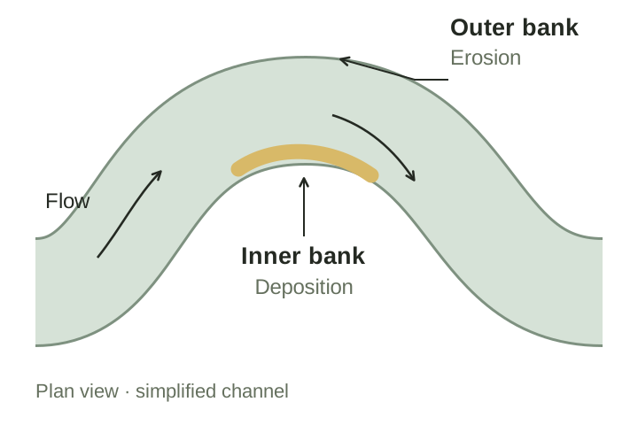
In a typical freely meandering river, erosion is concentrated along the outer bank of a bend, while sediment accumulates on the inside. The eroding edge is called a cut bank. The deposit on the inner curve is a point bar, often made of sand or gravel. As one bank retreats and the other builds out, the channel shifts across its floodplain. Bends can also move downstream. 1
This is easier to picture if you separate the moving water from the channel carrying it. Water keeps passing through the bend while its banks change as material is removed and deposited over many flows. The river is not carrying its entire curve bodily across the valley. It is excavating a new edge and adding material to another. 1
The familiar outer-bank and inner-bank pattern is a useful first description. It does not mean the river has one speed on each side, or that every grain removed from an outer bank settles directly opposite it. The flow and the sediment continue downstream through a sequence of bends.
The flow is three-dimensional
From above, a river appears to move mainly along its channel. Within a bend, water also moves sideways and vertically. Curvature, pressure differences, friction and turbulence produce secondary circulation: cross-channel motion superimposed on the main downstream flow. In the classic simplified pattern, near-surface water moves towards the outer bank and water nearer the bed returns towards the inner bank. These motions help redistribute momentum and sediment. 2
That pattern is not a complete description of every bend. The shape of the bed changes the flow, and the flow changes the bed. Additional circulation cells can develop. In a study using computer simulations of 42 idealised meandering rivers, researchers found that the locations of erosion and deposition varied with bend geometry. They also found that a map of bed shear stress alone could not explain the final bed shape: sediment transport had to be considered too. 2
The simulations used simplifying assumptions, including fixed banks and a single sediment grain size. They help explain the processes, but they are not a forecast of where a particular natural river will move next. 2
What the valley allows
The same current will not produce the same change in every bank. A loose sandbank, a cohesive clay bank and an armoured bank protected by large stones offer different resistance. Vegetation, woody debris, channel depth, the amount of water flowing through and the supply of sediment all affect migration. Those are among the inputs used by the US Bureau of Reclamation's SRH-Meander model. 3
This helps explain why a river cannot be understood from its curves alone. A bank may resist erosion because of its material or protection, even when a neighbouring section retreats. Removing floodplain vegetation can accelerate movement; installing bank protection can restrict it. A change upstream can also alter the water or sediment arriving at the bend. 3
A river engineer therefore needs more than an aerial photograph to estimate future movement. The Bureau's model considers changing flows over time alongside channel geometry and bank properties. Its published assumptions and limitations matter as much as the map it produces. Its forecast depends on the conditions assumed for the calculation. 3
When a loop is abandoned
A migrating bend can eventually be bypassed by a shorter channel, leaving the old loop partly or fully separated from the main flow. Water remaining in an abandoned meander can form an oxbow lake. At Vicksburg, the 1876 change came when the river cut across the peninsula rather than continuing around it. Such changes can occur abruptly even though the channel has been developing for much longer. 5
An abandoned bend may remain visible after it is no longer part of the main river. Oxbow lakes can provide marshland habitat, while the outline of an older channel records a route that a modern road map may barely acknowledge. 5
A floodplain contains earlier rivers
Sediment moves in different ways. Fine particles can remain suspended by turbulence; other grains roll, slide or bounce along the bed. The distinction depends on both particle size and flow conditions. During energetic flows, even relatively coarse material can be suspended. Changes in the amount and type of sediment delivered from upstream can therefore change the channel itself. 4
Meandering is only one possible channel pattern. Rivers may be relatively straight, divide around shifting bars in braided channels, or occupy more persistent branching networks. Bedrock channels and small steep streams behave differently from rivers crossing broad alluvial floodplains. Channel form reflects geology, slope, water supply and sediment, rather than a universal rule that every river must develop loops. 4
Natural channel movement is not automatically evidence of a damaged or unstable river. For some river types it is part of their ordinary behaviour. This distinction matters when interpreting old photographs or deciding where to build: a floodplain records more than the water visible on the day it was surveyed. Its abandoned channels and deposits are evidence that the river has occupied other ground before. 4
Sources
- National Park Service — Fluvial Features: Meandering Stream (opens in a new tab)
- Khosronejad and colleagues (2023) — On the Morphodynamics of a Wide Class of Large-Scale Meandering Rivers (opens in a new tab)
- US Bureau of Reclamation — SRH-Meander (opens in a new tab)
- Lord, Germanoski and Allmendinger — Monitoring River Systems and Fluvial Landforms (opens in a new tab)
- Vicksburg National Military Park — Course Changes of the Mississippi River (opens in a new tab)